Days 2,3 & 4 Calitzdorp to Prince Albert 090924 Thursday to 090926 Saturday 98km 3h 30min

Notice the lichen & red colour. This is on the gravel road from Carlitzdorp to the Swartberg Pass via Kruisrivier. But looking it up on Mapsource as I write this I see there is another exceedingly interesting road that starts directly from Calitzdorp also going via Kruisrivier. I went up the R62 for a bit before turning off.
This is called Red Stone Hills

A bit past the Red Hills. I have seen a colour slide presentation of Gamkaskloof (‘Die Hel’ but I don’t like that name as it is insulting to the previous occupants) before the road was built and this is very similar to that. Gamkaskloof was intensely farmed using animal drawn ploughs (and manual ploughs also) so the fields were small with the sides of the mountains very close. Now it is just a thorn tree wasteland – nothing like it used to be unless you get to the last farm in the valley.

I adore scenes like this. A simple humble Cape building in a Cape setting.

A bit grander. A very simple gable over the door and a nice green corrugated iron roof in place of the original thatch roof.

Closer to the Swartberg.

Swartberg pass going up the south side.

Swartberg pass along the top.

Swartberg pass snaking down the northern side. I prefer the northern side.


The Swartberg pass is sedimentary rock. Here, what were originally horizontal layers have been so folded by continental plate movements (plate tectonics ) that they are now vertical. Much folding to the left background.
I had to be in Prince Albert by 2 o’clock to join the Vernacular Architecture Society of South Africa (Volksboukundige Vereeniging van Suid-Afrika ) who had organised a four day excursion in the area. What follows are just some pictures from that excursion. My wife is a member and we went by car with another couple.
I have made a separate post about the geology of the Karoo . Later in the day I was shown this:
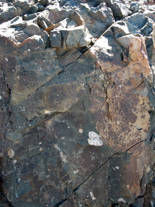

The grey is the rock flour made by the glacier as it slid down the mountain (labelled fine rock flour in the diagram) and included are the stones and pebbles – all those white specs are not lichen; they are the ‘boulders dropped from melting iceberg’ in the diagram. Known as Dwyka rocks.

There are 18 gabled houses in Prince Albert built between 1840 & 1860. It appears that one man, Carl Lotz, built most of them as they all have a distinctive feature; the horizontal moulding across the middle above the window. This style is known as the Prince Albert style as is unique to the town. All the gables are different but 8 of them have that feature. This is 88 Kerkstraat. 1857

Number 1 Kerkstraat. 1856. Tall slim Prince Albert gable.

This is Welgeleegen (previously Baviaanskloof) outside Prince Albert. It was built in 1837 (before the gabled houses in town) by G. S. Gouws. It is still in the Gouws family but the property has been subdivided over the years to distribute it amongst the children and now it is too small to generate a good income. Especially as much of the soil on the arable land was washed away in floods these last few years.

Mr Gouws, the present owner. Very friendly person.

This is particularly interesting – a hedge of pomegranates. There was no bathroom or lavatory in this house until recently; women went through that hedge to do their ablutions and the men walked down towards the river (behind me where I was taking this photograph). Some years ago (late 1980s or early 1990s) the present owner added on a bathroom & was forced to demolish it by the National Monuments Council (or South African Heritage Resources Agency (SAHRA)) as they had not approved the plans. Very recently they have built a bathroom inside the house. Mr Gouws told us his children got quite a shock when they went to boarding school and had to wash themselves in hot water – they were quite used to cold water all their lives up until then – Prince Albert is COLD in winter. Tough girls.

Zeekoegat near Meiringspoort. That is a private church on the left built by Frederick Oosthuizen at his own expense for the 100 church members in the district. I am a fan of corrugated iron buildings so photographed the church hall next door. Beautiful in its simplicity, built in 1929.

Tierberg, now unoccupied. One of the features of this trip through the Karoo is the large number of buildings that have been abandoned. This is unoccupied but still cared for but many have been abandoned completely.

This is the road to the Gamkapoort dam from the Prince Albert side. There is a proper ride report about it *here*. Originally it linked up with Bosluiskloof (what a great name) but the road was flooded by the dam.

Same road looking back the way we came in.


.
No comments:
Post a Comment