Sak River Day 7 Williston to Verneukpan 090929 Tuesday 320km 8h 44m
I stayed in the B&B of Elsa van Schalkwyk. She told me that there was a nice restaurant in the village. Had I not been told I think I would have hesitated before ordering food. What was off putting was the decor. There were hand made posters on the wall for gospel singers and a rugby club outing, things like that. The floor was yellow and white Marley tiles as wide diagonal bands across the place with pine tables and chairs. The bar counter was in the corner behind the door with a not very interested overweight barman watching WWF wrestling. There was an opening without a door to the room next door that seemed to be an old hairdressing salon as there appeared to be fittings for about 5 of those hair washing basin things – surely not! The best bit was the hanging ‘bamboo’ curtain in the window behind the bar – it was made of pieces of braai wood joined together with cup hooks screwed into the ends of each. Taking Elsa’s word I ordered beer & food & wine when the food arrived. It was great. I kick myself for not going back to get my camera to record the place. These sort of places are becoming scarce as they are being replaced by franchise chains like Spur, Steer, Wimpy and MacDonalds. I avoid those places as they are all exactly the same with the decor devised by some ‘designer’ in the pay of the corporation and are completely characterless. I have yet to eat anything in a MacDonalds & it is one of my ambitions to never do so. One of the best road reports I have read is on Adventure Rider; it is about a trip from Hong Kong to Tibet and it records the villages passed through and also the suppers they had. There is a tremendous variety of food in China as you move from place to place & this guy lovingly recorded it. We don’t have those local variations but I want to record these sort of places when I next go there as they will be gone soon. That Chinese ride report is *here*
After a nice breakfast cooked by Elsa I was off. She is the dowager of a farm just as I entered the village the previous day. She has great interest and pride in the farm and the area and has written 13 typed page guide for a walking tour of the farm; she gave me a copy – I will post a OCR scan of the first part of it as the next post on this thread; it is in Afrikaans which will suit many here and it amplifies some of what I have written.
ZAKRIVIER
Die Zakrivier ontspring in die Nuweveldsberge, en vloei slegs na goeie reen – ongeveer 300 min per jaar. By Groot Vloer tussen Brandvlei en Kenhardt soeei die rivier oor 'n afstand van 450 km.
Voor Desember 1847 was die Zakrivier die Noordelike grens van die Kaapkolonie.
Williston (voorheen Amandelboom), net sons die plase Walkraal, Kqffirskjoor en Bokwater wat u gaan besoek, was toe buite die koloniale gebied gelee. Die streek,wat gedurende die 19de eeu in die wandel bekencligestaan het as die Achterveld, Achterw8reld of doodgewoon Kareeberge, was op daardie tydstip die gedwonge toevlugsoord vir talle nomadiese veeherdersgroepe en enkele groepies Boesmans. Die Boesmans het verwoed teenstand gebied teen die indringing van veeherders in die gebied wat die wild in hulle jaggebiede uitgeroei het en die alters skaars waterbronne In die Kareeberge beset het.
Narrate die Boesmanweerstand in die streek gedurende die eerste helfte van die 19de eeu dear middel van meedoenlose kommando-aarivalle verbreek is, het steeds meer veeboere uit (lie aanliggende Nuweveld, Roggeveld en Hantam seisoenaal met hul vee in die gebied rondgetrek. Aan die voorpunt van hierdie veeboermigrasies het'n groot aantal!Basters asook verarmdes uit die blanks sektor gestaan. Die meeste van hierdie mense was nie opgewasse teen die korlipetisie vir grond in die digbevolkte omliggende distrikte rile. Gevolglik is hulle oor die noordelike grens van die kolonie gedruk en het hulle'n meer permanente swerwersbestaan in die Achterveld'gevoer. Teen 1845 het honderde Basters met hul vee in die Achterveld rondgeswerf en die handjievol permanente waterbronne van die streek beset. 'Tussen die seisoenale intrekkers A die aanliggende distrikte en die Bastergemeenskapr' het dikwels groot wrywing geheers oor toegang tot die beperkte water en welding van die streek. Veral tydens droogtes het gemoedere tussen die kompeterende groepe dikwels hoog geloop.
In die loop van 1843 het die Rynse Send inggenootska p op uitnodiging van die Kareebergbasters 'n kommissie van ondersoek na die gebied gestuur om die wenslikheid van 'n sendingstasie in die Kareeberge te ondersoek. Dit het uitgeloop op die stigting van die Amandelboom sendingstasie in Desember 1845 toe twee Dube sendelinge, eerwaardes Lutz en Beinecke, op Amandelboom gevestig het. Die doel van die sendingstasie was om 'n gevestigde Christelike gerneente onder die Basters te vestig.
Om in die geestelike behoeftes van 'n nomadiese gemeenskap te,voldoen was een van die g'footscte problems waarmee die sendelinge van meet ;if aan opgesaal was. Dit sou irnmers bale moeilik wees om mense wat voortdurend op trek was, suksesvol te bearbei en gedurig onder streng kerklike toesig te hou., Gevolglik het die Rynse sendelinge vanuit die staanspoor planne beraam om die nomadiese veeboere meer permanent te probeervestig. Die moontlikheid om hulle gemeente van-nomadiese veeboere tot gevestigde landboOers te verander, het in die Zakrivier gels. In hulle voortvarende inisiatief en met alle goei& bedoelinge het die sendelinge egter dikwels projekte aangepak wat direk in konflik was met die bards werklikhede van 'n semi woestyn. Toe die Zakrivier die eerste keer na hulle vestiging sy walle oorstroom het, het die sendelinge opgewonde dit in die vdoruitsig gestel om groot landerye vir graanverbouing op die vloedvlaktes van die rivier aan te 16. As daarin geslaag kon word om groot hoeveelhede koring te verbou, is in sendinggeledere geredeneer, sou dit 'n gevestigde gemeenskap in die hand werk en die alewige rondtrekkery agter vee uitskakel. Op inisiatief van eerwaarde Beinecke is mettertyd sells slulswerke en'n leidamstelsel aangel8 om water uit die Zakrivier te keer. Hierdie metode wat op presies dieselfde beginsel werk as wat deur die antieke Egiptenare langs die Nyl toegepas is, is steeds in gebruik.
Helaas het die Eurosentriese sendelinge nooit heeltemal daarmee rekening gehou dat in die Kareebergstreek in die reel Meer slegte as, goeie rednseisoene voorkom, en dat slags periodiek voldoende neerslag vat wat die Zakrivier laat stroom. Hoewel groot hoeveelhede koring sours langs die Zakrivier verbou is, kon die sendelinge nie daarin slaag om hul nomadiese veeherders¬gerneente in gevestigde landbouers te verander nie. Daarvoor was die reenval in die streak in die eerste plek net te wisselvallig. Daarbenewens was die 19de-eeuse veeboere ook te verknog aan hulle'vetstertskape,wat in feitlik al hulle daaglikse behoeftes voorsien het. Vir die meeste 19de-eeuse veeboere was vleis doodgewoon stapelvoedsel en brood 'n luukse waarsonder vir maande lank klaargekom kon word. Gevolglik het die sendelinge se tuinmaakidees, ten koste van veeboerdery, nie geredelik ingang gevind nie. By geleentheid het eerwaarde Beinecke byvoorbeeld geskok in sy dagboek k van 'n man vermeld wat so verknog was aan sy vleisdie6t dat hy dit prontuit gestel het dat hy sy mond nie aan brood sou sit nie omdat dit vir hum net soos klei gesmaak het. Vir hierdie man het eerwaarde Lutz se gereelde preke tydens droogtes dat "die liewe God dit weer goad geag het om die Easters se broodmandfle ietwat hoer te hang"' kennelik min indruk gemaak!
Totdat die Bastergemeenskap gedurende die 1860's uit die gebied weggetrek het, het die Zakrivier nietemin 'n belangrike rot in die leavens van die sendinggemeente gespeel. In die "boom- en waterlose woestyn", soos die sendelinge telkens die gebied getipeer het, was vioeiende water altycl 'n groot bron van vreugde. Wanneer die Zakrivier na droogtesiklusse weer stark gevloei het en sy walle oorstroom het, het die hale sendinggemeenteby die eerste berigte datdie rivier aan,die "afkom" was, afgesit rivier toe om die skouspel te aanskou. Normaalweg het eerwaarde Lutz 'n Idanksegglngscliens gehou waarna die toehoorders hulle in die oorvloed water kon verlustig. Inwoners van Amandelboom het ook nooit die geleentheid laat glip om, uitgedos in hulle kiskiere, belangrike besoekers aan Amandelboom by die Zakrivier in te wag en under psalmgesang te verwelkom nie. Spoggerige perderuiters en baldadige skoolkinders het clan die uitgeputte reisigers tot by die kerk vergesel.

The museum was the Mission church. In 1768 Johan Abraham Nel planted an almond tree in honour of his son’s birth. (That date shows he was up here pretty early on.) This tree eventually became enormous, and was an oasis in the dry treeless area of the Sak river. Later in 1845 Johann Heinrich Lutz established a mission station named Amandelboom (almond tree) at this spot. When white farmers later moved in they had no church of their own so the mission congregation invited them to use their church. Elsa told me that this is the only congregation in South Africa where the white congregation were originally members of a mixed congregation. In 1883 the name changed to Williston but the coloured part of town is still known as Amandelboom.

I really liked this fence at the museum. Those are the heads of drilling machines. Much bigger than water boreholes, I have no idea what they would have been used for in this area. Anybody with something to say about them?

Elsa told me that the museum curator ran a project for children of the coloured township of Amandlesfontein to paint the vibracrete wall of the sports ground in 2008. They had to demonstrate on paper what they were going to paint so only those with some ability were chosen to paint. The community is very proud of the wall and when someone put graffiti on the wall the community tracked him down & had the police deal with him. By getting the community involved the curator ensured that they identified with and took possession of the project so they now look after it. If you just give or impose something on a community they never identify with and cherish that thing.

But look over the fence at the state of the soccer field. SAFA has done nothing to promote soccer at grass roots level & should be hauled before the sports committee at Parliament to answer why & be held accountable. To get a good national team you have to start by training school children, then club players and on to provincial level. SAFA has done nothing to assist and improve soccer at a local level – if you don’t water the roots there will be no crop to reap.

Outside Williston I took this red-dashed road – the Sak is over the brow of the slope.

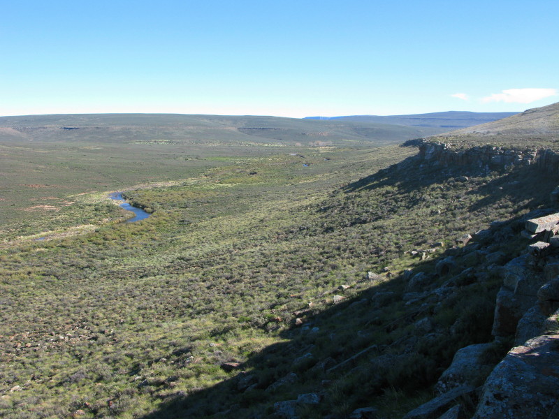
The Sak at Bruinskop. Wide, shallow and sandy without surface water.

A bit further on. That is the ‘valley’ of the Sak behind. If you want to ride nice verlate roads then go to the Groot Karoo.

This photo shows the beginning of the massive floodplain of the Sak river. Later on it becomes the Grootvloer (north of Brandvlei) then the river’s name changes to Hartbeesrivier before Kenhardt. (Mapsource uses Grondvloer instead of Grootvloer.)

I come out of the red dashed road to join the R353

A bit further on the R353 does a T junction where the left road leads to Sakrivier rail terminus (long since unused). That road crosses the Sak where it looks like this and a little further on it joins with the Vis river which has come down from Sutherland.

Sakrivier rail terminus. The last train came here a long time ago.

This is the Sak river just outside Brandvlei. It has now gained water from the Vis river which joined it a bit further upstream.
The Vis river. This picture was taken on another trip. There is much more rain along the western side of the Great Karoo plain which collects in the Vis river. It runs in a wide and deep valley. The rain that falls along the western escarpment but not further east is what limited how far east the trekboere went. In summer they came up here and grazed their animals but in winter they went down to the Onder Karoo (Tankwa Karoo) where they had legplaats. A legplaats was their farm down in the lowlands where they spent the winter but in summer they drove their animals up the Gannaga, Ouberg or Verlaatekloof passes up the Roggeberg to be in the Groot Karoo. They could not drive their animals much past the Sak river because of the lack of water and good grazing.
Here is a little information about the three groups, the Khoikhoi, San & trekboers.
Khoikhoi
Firstly the Khoikhoi. Currently it is politically correct to refer to Hottentots as Khokhoi. The Khoikhoi were pastoralist herders with flocks of sheep and herds of cattle. They were migratory, moving about with the seasons following the best available grazing. Their living shelters were made of reed mats on a framework of sticks stuck into the ground.

That is a modern reconstruction so is in pristine condition.

These are recent scruffy ones where modern materials are replacing the traditional reed mats.
San
The next group are the San; formally known as the bushmen. The San were hunter gatherers – they hunted game and collected veldkos; they did not plant crops or keep any animals. The San were an egalitarian society – they had no hierarchy; everyone was equal. They lived in small groups of between 6 and 30 people with 13 been about average. They had very few possessions; being migratory their shelters were made of a reed covered framework that could easily be carried along as they moved.

This is a modern San building (check the clothes) in Botswana. The ones drawn in the Karoo often were flat sided simple pitched roof style.

This picture is of one in the Kalahari.
They often used rock overhangs as shelters.
Khoisan
The Khoisan is a collective name covering both the Khoikhoi and the San used when it is either not certain which were involved, or when both were involved or when talking about both communities as a single group. Both groups were migratory; the Khoikhoi taking their animals to where the grazing was as the seasons changed and the San following the game as they moved around in response to the changing seasons. They lived in the same areas amicably most of the time as they were not competing for the same resources – except water at times.
Trekboers
The Trekboers were similar to the Khoikhoi in that they too were herders but they were largely of European origin. The big difference was they had horses, wagons and some guns (ammunition in short supply).
This source has a good description of the trekboer life. (If you are a van Rensburg then it should particularly interest you.) I can not give the url for the best page but look at member e6 (left hand menu) page 2 for good description of their life and that is where the pictures below come from.
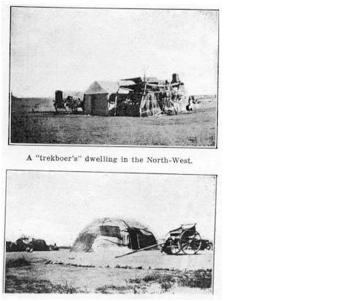
The matjieshuis in the lower photograph is no different to what the Khoikhoi used. It was simply a home made tent really.
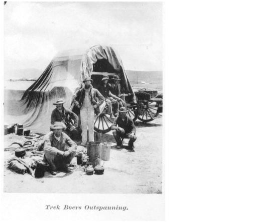
The wagon was the basis of home life.
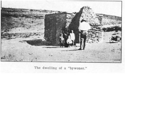
This is interesting because it is one of the corbelled buildings I showed yesterday.
-----------------------------------
If you look back at the picture of the Sak River Mission in yesterday’s post you will see that there are several matjieshuise in it. They could be used by any of the three groups discussed here.

That is the beginning of the Grootvloer in the background before Brandvlei. In flood the Sak gets lost in the Grootvloer. Think back to that geology picture of the flood plains. When that was taking place this place teemed with animals, there was some huge catastrophy 251 million years ago when 96% of all species became extinct – including plants. This is long before the dinosaurs developed – they died in a later (much smaller) mass extinction. Slowly vegetation recovered, but it takes millions of years for new plants to evolve to replace the extinct ones and the sedimentation changes slowly to record this.

From Brandvlei I decided to go to Verneukpan. It is a place I have wanted to see since I was at junior school and read about Malcolm Campbell’s land speed record attempt (his son Donald was setting water speed records at the time which led me to know about his father’s attempt at Verneukpan). That is a small pan on the way there from Brandvlei.

That is the beginning of the pan in the distance.

When you come in from the Brandvlei side there is a notice board about the Camp. I had read posts on WD & knew to ignore that as the half of the pan this side is exploited by the landowner but on the other half you have free access. But that is the pan right there – this photo was taken close to the fence between the farms around the middle of the pan looking back the way I had come.
http://en.wikipedia.org/wiki/Verneukpan

That is a notice board giving details of Campbell’s record (he did not beat the world absolute speed record but did create a new 8km record).

The speed track is behind the locked gate with my sporty machine in front.

On the opposite side of the road to the 1929 speed track there is no fence & you can ride onto the pan.

Showing what the surface is like.

I got a puncture soon after I left Verneukpan. My topbox is now the center stand (the black thing in front of it is the seat).

After fitting the spare tube I moved a bit away from the road & pitched tent. That topbox case is now my stool. Later I sat on the seat leaning back against the warm bike as the air cooled after sunset.

If I zoom in i can show that I had nice John West tuna salad, La Motte Millenium 2003 in a proper wine glass for supper. Wind got up in the night but I put my riding jacket over the sleeping bag and was soon as warm as ever.


.
No comments:
Post a Comment