Southern Africa has one of the longest records of human activity anywhere in the world. The Swellendam region in the Overberg is rich in historic sites dating from over 1 million years ago to more recent colonial settlements. The later Stone Age can be linked to the Khoi Khoi who, in the Swellendam region of the Overberg was known as the Hessequa. This name translated means “people of the trees”.
The Hessequa entered the Overberg region some 2,000 years ago. They were a clan of herders; farming fat tailed sheep and long horn cattle. The Hessequa’s moved freely across the western area of the Overberg and lived on the banks of the Breede River where they grazed their large herds.
Since my last visit things around here have been changing. The winter crops are starting to appear and the whole area is coming alive. As stated before my first photo was taken on the 1st of March 2012:
During the days of ensign Beutler this was one of the main routes from Cape Town to Swellendam. It crossed the Zonderendriver at a low-level crossing I located on a farm now called Vaandrighsdrift, on the other side of the river. Here wagons had to camp for days waiting for the river to run down only to be confronted by a full Breede River 8km further on.
Driving past the Vaandrigsdrif road sign and seeing the change every week I knew I needed to continue my search for the actual Vaandrigsdrif at the first possible opportunity. As it happens, today would be that day!
I was early again and had a couple of hours to spare. On top of that I had a suitable vehicle - a GWM H5. The car was sparkling clean (even the tyres were polished) so I had to get my photographs before I hit the gravel roads.
The "before" photo. I my opinion vehicles like these are for adventure, so it's not going to stay sparkling for long.
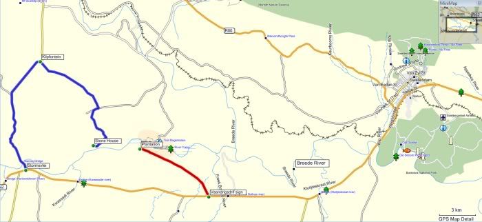
It might be a good idea at this stage to mention that this was not a planned event. The fact that my search continued today happened purely by chance. I have never been on the roads I was headed towards. I had no map and no off-road GPS, only a general idea of where I should be - the other side of the river! So, on my way back to George I took the R317 road off the N2 and crossed the Sonderend River near Stormsvlei.
This road meanders through the mountains via this poort and being is exploring mode I just had to stop for a pic.
The plains on the other side. It makes sense that travellers and explorers would have travelled here rather than on the Southern Side of the mountain range as the Flora here would have been less dense.
Eventually the road I took wasn't even fenced off. Now I'm roaming free.
I stop at a farmstead to ask about the road towards the river and the friendly owners show me the way - look at this! They have a lovely stone house they rent out as self-catering accommodation.
Nice fireplace and everything you need.
The house even has two fishing rods if you want to fish in the river. And what a spot!
This would make a perfect weekend getaway for the family.
It is not Vaandrigsdrif though. As it turns out Vaandrigdrif is further East, but what a beautiful area I find myself in.
Some more pics of this area:
I love this pic!

So, with all the stops and exploring and photos I used up all my available time and had to start heading back.


No comments:
Post a Comment